hurrikane18
Member
- Location
- Saskatchewan
Hello!
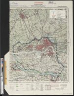
Let me share with you my original WWII German Panzer map of Rotterdam titled “Defended District of Rotterdam”. First, a brief story:
Lieutenant-Colonel Keltie Kennedy fought for Canada in WWI. He enlisted in St. John on May 1, 1916, at the age of 17. I have a copy of his diary from 1916-1917. When World War II broke out, being in the militia, he was called to serve under the National Defense Act.
His son (Clifford Kennedy) was surrounded by the military from a very young age. As a WWI veteran, his father would often have old wartime friends over to reminisce. Clifford learned about map reading, scouting, weapons training, drills, and organization. Mr. Kennedy had made a point of transferring his skills to his son. He learned how to read maps, the stars, and to tie knots. Clifford Kennedy enlisted in St. John on November 4, 1940. Like his father, he was only 17 years old when he enlisted.
During the last days of the war, Clifford Kennedy would find himself in a very interesting situation. He had served with the 7th Anti-Tank Regiment all through the Italian Campaign and the liberation of North-West Europe, but three weeks before the end of the war, on April 15, Clifford was made a captain and moved to the 1st Anti-Tank Regiment.
“Early in my posting to the 1st A/TK (Anti-Tank) Regiment, on April 28, 1945, I was ordered to carry out an unusual mission.”
The Germans had constructed a series of strong-holds that were heavily fortified. The Fuhrer himself had ordered that they be held at all cost. The mission entailed crossing over to the German lines with a large sealed manila envelope, which he was ordered to deliver to the German General in command of the remnants of the German Forces in Fortress Rotterdam. Clifford’s driver spoke German, and was from Kitchener, Ontario, and their escort consisted of three or four Canadian soldiers including an officer, plus a German-speaking Canadian staff officer. The contents of the letter were not made known to Clifford:
[In retrospect, and speaking with a degree of cynicism, honed from the experience of years, one might suggest that the thought of those who put the exercise in motion might have been that, since only a lowly Captain and his driver were involved if things went off the rails, the loss would not have been significant.]
The German party was cautiously awaiting the Canadians’ arrival at their forward defense lines. Separated from his driver, who was to wait at the cross-over point, Clifford was then accompanied by a German Staff Officer who “spoke excellent English.” They got along rather nicely, which was quite convenient because the drive was several miles long. During their conversation, Clifford learned that the German had, like his father, been a gunner in WWI. “Our conversation became quite animated, and he remarked on what good gunners the Canadians had been in both wars.”
They headed to the General’s Headquarters within the heart of the Fortress at Rotterdam. Leaving the scout car, passing two armed sentries, and heading through a “large main floor to an imposing stairway,” they entered the office. They had to wait a moment for the General, who was previously engaged. The sound of a buzzer announced their admittance to a corner office, “It was very imposing, with customary flags, maps and military paraphernalia.” Although the Staff Officer and the General spoke in German, Clifford sensed that the General was becoming infuriated with the introduction, “It showed in the immediate discoloration of his face and neck.” Indeed, as the German Staff Officer later informed Clifford, the General felt insulted that the Canadians had chosen a junior officer to deliver to him, a high ranking officer, such a letter. He was immediately escorted out to the Aide de Camp’s outer office while a discussion took place. The result was Clifford’s swift return to the Canadian lines, without a response to the dispatch.
The trip back lasted twenty-five minutes, and upon arrival, Clifford was greeted by the party he had left behind. “Some days later,” Clifford recalls, “on May 5th 1945, Lt. General Charles Foulkes, Commander of the Canadian Forces in North West Europe, accepted the signature of Colonel-General Johannes Blaskowitz. That signature marked the end of all German hostilities.”
After the war, this map returned to Canada with Clifford Kennedy, along with some other collectible items from the war. After he passed, this map was passed down through his family before it was gifted to me. Since it has been in my position, it’s been framed in solar protecting glass to help preserve it.
I’ve spent a fair bit of time trying to decipher the map with the help of my Oma and Opa (German grandparents). I will tell you what I THINK I figured out, but I also appreciate any corrections or other information anyone can tell me about this map!
I’ll start from the top: Map no. 50e titled Defended District of Rotterdam. Upper right of the title (in pencil) is the name “Oberst Polster”. Oberst: a military rank equivalent to Colonel. The last name Polster (after searching google), I believe to be Oberst Kurt Polster, who served with the Schützen-Regiment 66 of the 13th Panzer-Division from 1937-42. From 1943-44 he was commander of the Reserve-Panzergrenadier-Regiment 81 of the 179th Reserve-Panzer-Division. This division was disbanded in May 1944 to form the new 116th Panzer-Division in June of 1944 active in Normandy. According to the Wehrmacht rank lists of 1944 he was promoted to Oberst on Jan 10, 1943 and served at that time with Panzergrenadier-Regiment 66 active at the Eastern front. He was in Germany from June-July of 1944 for mental recovery. It is not clear where he served after July 1944. I believe this map belonged to him, though.
Other interesting features of this map: All of the colours you see shaded in this map appear to be done in coloured pencil. I can only imagine the time spent doing this. A lot of the markings and writings appear to be in pencil, coloured pencil, pen, and even marker. According to my Oma and Opa, who are fluent in German, this map contains a lot of acronyms, making it hard for even them to decipher. Pz. seems to be the abbreviation for Panzer, and we have a list of others. I’d love to hear what some of you might be able to translate as well though.
I hope you have enjoyed hearing what I THINK I know about this map, and look forward to hearing any contributions! Now, the pictures:
(Let me know if you want more pictures or closeups of anything)
Last edited: