









































You are using an out of date browser. It may not display this or other websites correctly.
You should upgrade or use an alternative browser.
You should upgrade or use an alternative browser.
hunting resource apps
- Thread starter Ωmega
- Start date

I went with the IHunter app and am very pleased with it. Simple stupid,even this old fart could figure it out. I found the crown land atlas slow to load and a pain in the ass to navigate.anyone here used/tried apps like 'huntscout' for locating crown land hunting spots ? are these apps that much easier than navigating the crown land use atlas, or are they just a waste of money ?
the crown land atlas is a headache and a half for sure. so with ihunter you were able to easily find crown hunting lands, their boundaries and all that ?I went with the IHunter app and am very pleased with it. Simple stupid,even this old fart could figure it out. I found the crown land atlas slow to load and a pain in the ass to navigate.
Yes. Ihunter shows parcels. Some parcels will be crown land, tho most are private. Some are statutory right of way like power lines. Also, if there's no parcel, it'll be crown land. In addition, you can see leased land, municipalities, and no shooting/hunting areas as well. I have found errors in it - for example some area around gold bridge is shown as no hunting/shooting but if you look at the bylaws discharge of firearms is exempted for hunting. Here's an example where iHunter is wrong, be its exceedingly rare and it lists the bylaw that you can double check with.
The govt should really provide a better service for this as government should make it easy and free for anyone to follow the law.
Ihunter is cheap worth every penny.
The govt should really provide a better service for this as government should make it easy and free for anyone to follow the law.
Ihunter is cheap worth every penny.
Attachments
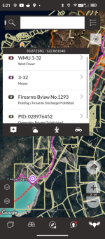
yea the gov resources are obscenely complicated and confusing. thanks for the info on ihunter, I'll check it out.Yes. Ihunter shows parcels. Some parcels will be crown land, tho most are private. Some are statutory right of way like power lines. Also, if there's no parcel, it'll be crown land. In addition, you can see leased land, municipalities, and no shooting/hunting areas as well. I have found errors in it - for example some area around gold bridge is shown as no hunting/shooting but if you look at the bylaws discharge of firearms is exempted for hunting. Here's an example where iHunter is wrong, be its exceedingly rare and it lists the bylaw that you can double check with.
The govt should really provide a better service for this as government should make it easy and free for anyone to follow the law.
Ihunter is cheap worth every penny.

Why would one not use "All" available resources or at least more than one resource to research a prospective area to hunt ?the crown land atlas is a headache and a half for sure. so with ihunter you were able to easily find crown hunting lands, their boundaries and all that ?
After the 2026 fire season there are several areas I travel that have burned are still burning that will not be fit for hunting for several years .
But, still worth researching the changes with boots on the ground in future.
Books, maps, electronic aides may come in handy for references and cross references... along with local knowledge.
Be safe out there folks, it is an ever changing environment.
agree 100% an app would/should be a complimentary resource, not an exclusive one. the crown atlas will always be the gold standard, but anything that makes it easier to navigate is an asset.Why would one not use "All" available resources or at least more than one resource to research a prospective area to hunt ?
After the 2026 fire season there are several areas I travel that have burned are still burning that will not be fit for hunting for several years .
But, still worth researching the changes with boots on the ground in future.
Books, maps, electronic aides may come in handy for references and cross references... along with local knowledge.
Be safe out there folks, it is an ever changing environment.


I use Ihunter. Shows all the property lines and crown land for Ontario.
I have all our trails and stands saved on it. I can share it with anyone I'm hunting with so they have all same info. If you turn on GPS you can track each other as well (hard on battery life though)
I have all our trails and stands saved on it. I can share it with anyone I'm hunting with so they have all same info. If you turn on GPS you can track each other as well (hard on battery life though)